Real-time network data from the NetBlocks internet observatory show connectivity outages caused by Hurricane Dorian as the Category 5 storm approaches the Bahamas as of 3:00 p.m. UTC Sunday 1 September 2019.
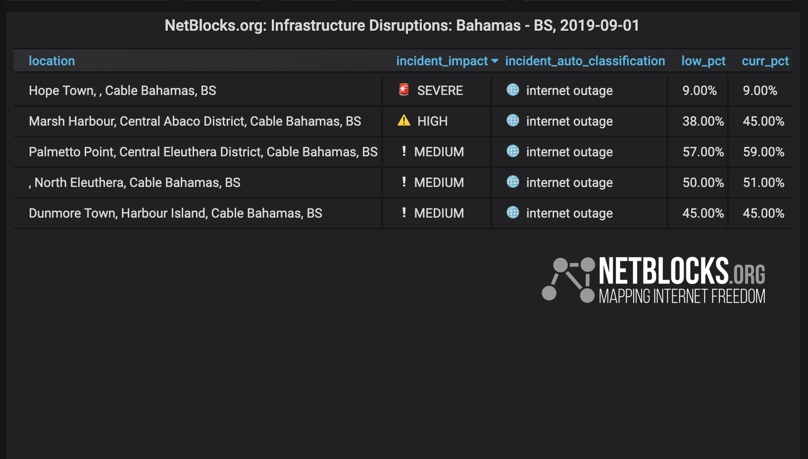
Live observations are being used to assess the technical and geographic impact of Hurricane Dorian, to trace the storm’s progress and to gauging the resilience of online emergency response mechanisms in affected states. Detections commence Sunday as critical infrastructure in Hope Town falters from 12:30 a.m. UTC:
⚠️Alert: Hurricane #Dorian has started to knock out internet infrastructure across the #Bahamas as the Category 5 storm approaches #Abaco with devastating 180 mph winds
Major outages now registered in #HopeTown and #MarshHarbour with landfall imminent
? https://t.co/tIrHhZGpUy pic.twitter.com/L4OxhDL6pQ
— NetBlocks (@netblocks) September 1, 2019
Abaco Islands network connectivity falls to register below 6% in some areas as of 4:00 p.m. UTC:
Real-time network data shows rising impact of #HurricaneDorian with critical infrastructure in #HopeTown faltering from 12:30 a.m. UTC and disruptions intensifying through recent hours; #AbacoIslands network connectivity now below 6% in some areas ?
— NetBlocks (@netblocks) September 1, 2019
? https://t.co/tIrHhZGpUy pic.twitter.com/qiVPThgtr4
The outages are attributed to a combination of localized residential power cuts, identified by the gradual fall in the chart in the earlier hours of the day, as well as wider infrastructure disruptions that have caused the more abrupt declines in connectivity.
Update – 6:40 p.m. UTC: Hope Town has fallen off the internet in large part, with real-time network data showing 0% connectivity amid reports of a “direct hit” from Hurricane Dorian.
Little to no information currently appears to be emerging from affected areas online, with social media accounts that had been covering the island town now silent:
Update: #HopeTown has fallen off the internet: real-time network data now show 0% connectivity amid reports of 'direct hit' from Hurricane #Dorian; little to no information currently emerging from affected #Abaco #Bahamas impact zone ?
— NetBlocks (@netblocks) September 1, 2019
? https://t.co/tIrHhZGpUy pic.twitter.com/DWVInxLyYR
Torrential rain and storm surges are expected last for days, potentially progressing to impact millions in the U.S. along the Southeast coast from Florida to North Carolina.
Various online emergency resources appeared to be overloaded by user traffic for parts of the day, with edge measurement data showing South Carolina’s SCEMD information site becoming slowing to access for a period of approximately one hour after the announcement of mandatory evacuation plans:
Online emergency resources appeared to be overloaded by user traffic for parts of the day, with network data showing South Carolina's @SCEMD information site slowing for ~1hr after the announcement of Hurricane #Dorian mandatory evacuation plans⏱
— NetBlocks (@netblocks) September 2, 2019
? https://t.co/tIrHhZGpUy pic.twitter.com/xYAtkAYd3X
Authorities have been using multiple channels aside from their official websites, including social media, mobile apps and broadcast in order to communicate evacuation measures:
We appreciate your patience while we work through technical difficulties on our websites. Below is a map of the area's evacuation zones; updates will be posted on this page. pic.twitter.com/2ycxLXKkfL
— City of Jacksonville (@CityofJax) September 1, 2019
Update: A severe telecommunications outage has been registered in Freeport at 2:00 a.m. UTC (10:00 p.m. Sunday local time) as Hurricane Dorian makes landfall on the eastern end of Grand Bahama amid widening power cuts:
⚠️Alert: Severe telecommunications outage registered in #Freeport at 2:00 a.m. UTC (10:00 p.m. local time) as Hurricane #Dorian makes landfall on eastern end of #GrandBahama amid widening #Bahamas power cuts
— NetBlocks (@netblocks) September 2, 2019
? https://t.co/tIrHhZGpUy pic.twitter.com/NntFfG8I8U
Update: A sharp drop in connectivity has been observed as of 7:30 a.m. UTC (3:30 a.m. local time) affecting Grand Bahama Island and having nationwide impact:
Confirmed: Nationwide collapse of connectivity registered in #Bahamas as of 7:30 a.m. UTC (3:30 a.m. local time) knocking out remaining networks; estimated 80% now offline amid power outages as infrastructure succumbs to Hurricane #Dorian
? Live Report: https://t.co/tIrHhZGpUy pic.twitter.com/jdEsN38Gq2
— NetBlocks (@netblocks) September 2, 2019
Update: Tuesday, 3 September 2019: Many parts of the Bahamas remain offline as of 9:30 a.m. UTC (5:30 a.m. local time) as Hurricane Dorian continues to impact Grand Bahama island. Network data show some restoration of communications in last 12 hours:
Update: Many parts of the #Bahamas remain offline as of 9:30 a.m. UTC (5:30 a.m. local time) as Hurricane #Dorian continues to impact #GrandBahama island; network data show some restoration of communications in last 12 hours #Freeport #MarshHarbour
? https://t.co/tIrHhZGpUy pic.twitter.com/Czn58ASG6V
— NetBlocks (@netblocks) September 3, 2019
In 2018, NetBlocks reported on the network impact of Hurricane Florence as it tore through North Carolina and in 2017 the mapping system was deployed to map Hurricanes Harvey and Irma.

Continued: Internet outages registered as Hurricane Dorian reaches U.S. East Coast
Methodology
NetBlocks diffscans, which map the IP address space of a country in real time, show internet connectivity levels and corresponding outages. Purposeful internet outages may have a distinct network pattern used by NetBlocks to determine and attribute the root cause of an outage, a process known as attribution which follows detection and classification stages.
NetBlocks is an internet monitor working at the intersection of digital rights, cyber-security and internet governance. Independent and non-partisan, NetBlocks strives to deliver a fair and inclusive digital future for all.
[ press | contact ] Graphics and visualizations are provided for fair use in unaltered form reflecting the meaning and intent in which they were published, with clear credit and source attribution to NetBlocks. Intellectual property rights are protected including but not limited to key findings, facts and figures, trademarks, copyrights, and original reporting, are held by NetBlocks. Citation and source attribution are required at the point of use.